
Boardman-Ottaway River Access Update
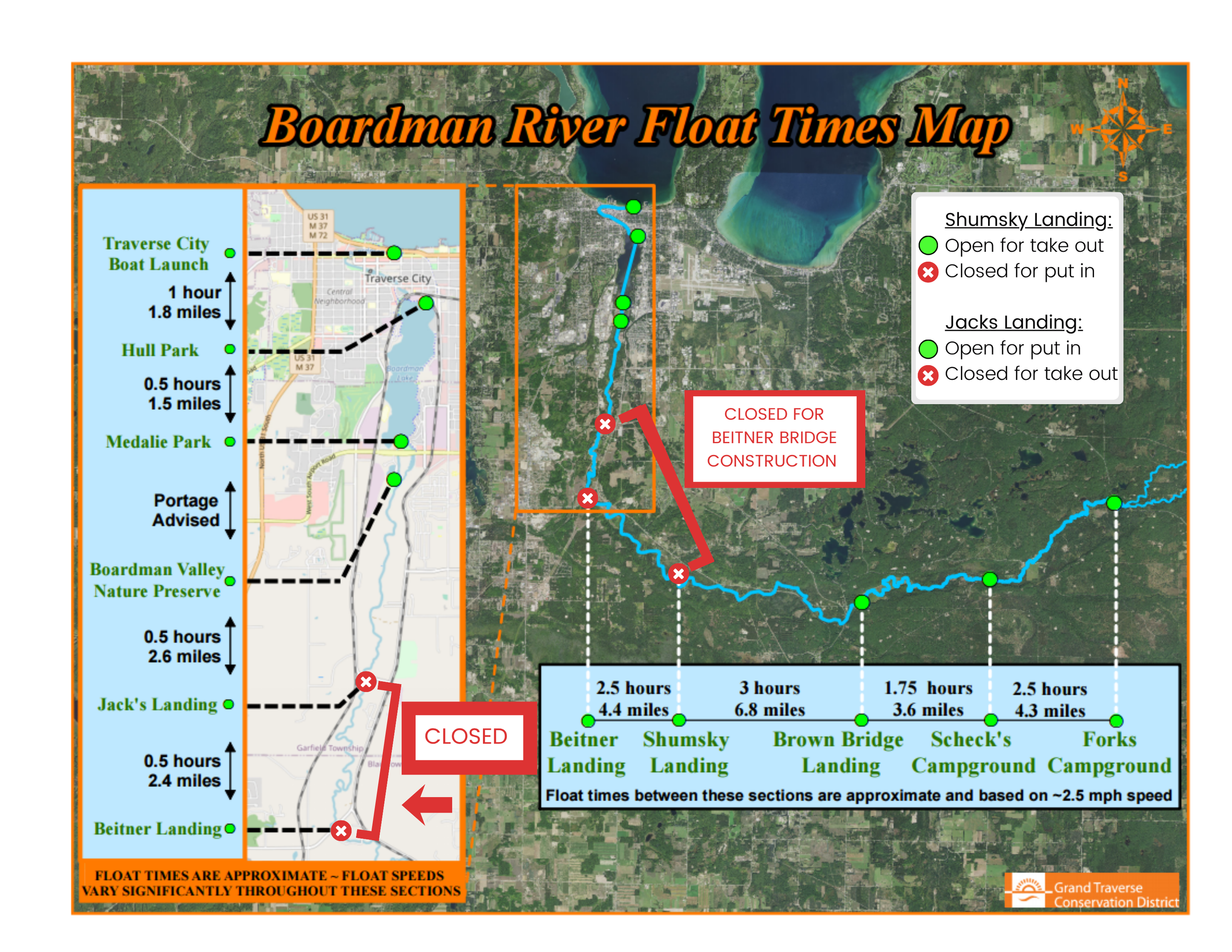
Beitner Canoe Launch is CLOSED until Beitner Bridge construction is complete and Beitner Rd reopens to the public. Ropes and buoys will remain across the river until bridge construction is completed.
Paddlers must take-out at Shumsky Landing. The river is closed for put-in from Shumsky Landing to Jack’s Landing.
The Boardman-Ottaway River was significantly impacted by the historic flooding event in April 2026. Although sections of the river are navigable, hazards, obstructions, and debris still exist. The river is constantly changing, and although trees have been cleared, new downed trees or obstructions are still possible. Always be alert and able to navigate around potential hazards or pull to the side.
Due to the small-sized culverts, we do not recommend floating under S. Airport Rd. in the culverts under any circumstances.
THE BOARDMAN-OTTAWAY RIVER
The Boardman-Ottaway River Watershed spans 287 square miles and drains approximately 182,800 acres of land through nearly 200 miles of river and stream tributaries. All of this adds up to 30% of the surface water input into Grand Traverse Bay, making it the largest tributary to Grand Traverse Bay’s West Arm.
A state-designated ‘Natural River’ and a Blue Ribbon trout stream, the Boardman-Ottaway River is considered one of the top ten trout streams in Michigan and one of the most outstanding natural features of the Grand Traverse region.
As such, the river and its watershed are enjoyed by anglers, boaters, hunters, hikers, and wildlife watchers alike.
LOOKING TO PADDLE THE BOARDMAN-OTTAWAY RIVER?
Learn more about paddling specific sections of the Boardman-Ottaway River below.
In addition, for many years now GTCD, in partnership with BackCountry North, offers a summer guided kayak float down a select section of the Boardman-Ottaway River. Check our Events page for more information on our guided float. Group paddles and seasoned knowledge of the Boardman are also available through the Traverse Area Paddle Club.

PADDLING the upper boardman-Ottaway river

PADDLING the middle boardman-ottaway river

PADDLING the lower boardman-ottaway river